Wednesday, October 12, 2011

GPS drawing


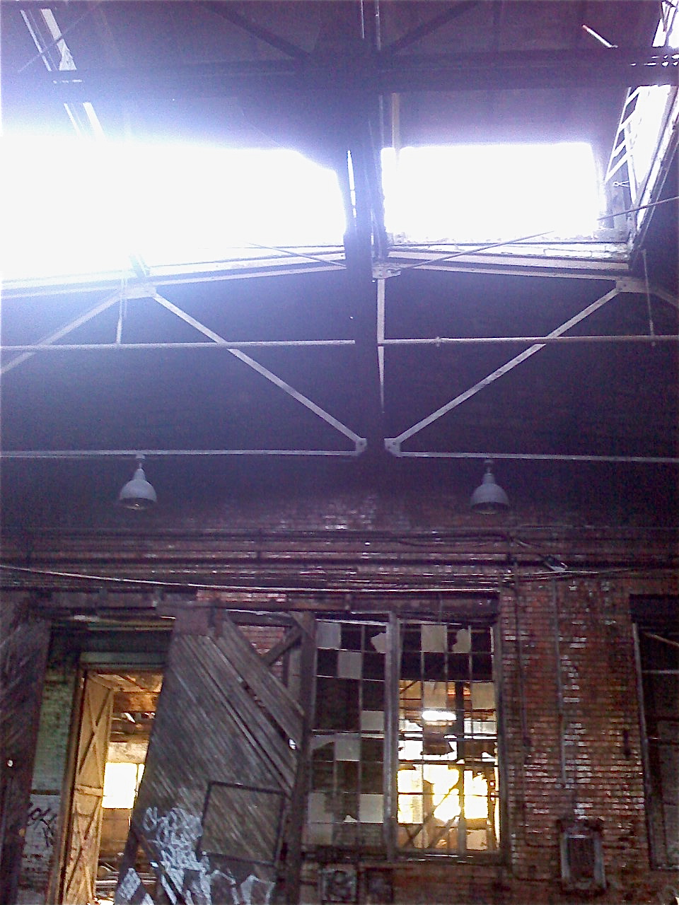
For the GPS drawing our group decided to split up into two separate smaller groups. One of the groups walked and one of the groups drove to our pre-determined destination. Each group had a set of guidelines that they could follow to get to their destination, for example having to make at least three u-turns before reaching your destination, or another rule even though it sounds silly was to get coffee. This rule turned out to be way more important but we overshot the destination and had to make a u-turn, so it worked out perfectly. Once we arrived at the pre-determined address we couldn't find the other half of our group. We knew that it was some sort of abandoned building but we didn't know where it was. After searching and we finally found the rest of our group amongst these abandoned buildings conversing with a few homeless men. As cool and as interesting of a place these abandoned buildings were I felt that I was an intruder of these homeless men space. Even though these buildings totally belong to someone else, these homeless men had clearly made these buildings their home. One of the homeless men throwing out threats that it wasn't a safe place to be, or that their was arsenic poisoning in the buildings. Whereas the other homeless man wanted to take us and show us all around the buildings. I thought overall the experience was very interesting, and doing the GPS drawing became more about the destination than the actual creation of a drawing.

Tuesday, October 11, 2011

GPS Drawing

We drove through every drive-thru on North Ave, from the intersection on North and Oakland to North and 67th. This is what we ate, so what?


Futuristic Settlers vs. the GPS Drawing

Our GPS drawing did not turn out the way we expected. Inspired by the Kwon and Rogoff readings, we decided to make a pseudo settlement on the beach. We connected early Milwaukee Fur Traders and the lake, and we were each going to make our own forts using the GPS drawing. However, the GPS in combonation with the Everytrail App was really uncooperative and wouldn't draw straight lines... it even marked us as standing out in the middle of Lake Michigan, which was completely incorrect. After multiple tries, our hopes of a virtually drawn lake settlement was terminated.

Brittany Kowalski, Brady Wolchansky, and Corey Smith: GPS Drawing

Our drawing was constructed by randomly chosing cars to follow.  Once we started to follow a car, we trailed it until it reached its destination.  At that point we picked a new car to follow.  The first car took us from MIAD to an apartment near UWM. The next car we followed turned a corner and parked.  The next car took us to a parking lot on the corner of Plankinton Ave and Kilbourn Ave.  Our final car led us to the Aurora West Allis Medical Center on Lincoln Ave.  In our car we discussed if the lead car's driver knew we were following him or her.  In addition, we hypothesized what his or hers destination was.

Our return trip to MIAD was significantly different than our original drawing.  This inspires questions about "the journey" one chooses to take to a destination.  How does one select a route?  How do we navigate?  Major influences include but are not limited to: available modes of transportation, access to technology, environmental factors, time, aesthetics, knowledge, preference, and personal experience.  While navigation is not uniquely human, our relationship with choice and travel is.  

Navigation has evolved from hardwired survival instincts into an amalgamation of complex components embodying individualism.

Monday, October 10, 2011

GPS Drawing

For our GPS drawing, we decided not to travel in any straight lines. Every time we came across an intersection, whether it be two streets or a street and an alley, etc. we took turns deciding whether to turn left or right. It was interesting to navigate the city in this way - we noticed a lot of buildings and backstreets that would otherwise go unnoticed on our usual routes. Funny thing was, as soon as we felt like we were getting somewhere entirely new and unfamiliar, a wrong turn onto the freeway put us right back where we started.

Thursday, October 6, 2011

Doors open Milwaukee

For doors open Milwaukee I went to the US Bank first. The view was neat, it's a bummer it was rain and foggy, I'm sure the Lake would have looked nice. The men that were working said they were thinking about having it open to the public more often.
The view wasn't the only cool thing about the bank. I really enjoyed the pipes in the building, it had an interesting mood.

Next I went to Hotel Foster. They had a really nice art collection.

The structure of the building was very interesting, even down to the carpets.

Wednesday, October 5, 2011

GPS Drawing: follow the trail of empty beer cans through the woods

Nikki's Awful City Forest Adventure


EveryTrail - Find the best Hiking near Milwaukee, Wisconsin


So I had the idea to try to make a peace sign using the locust street bridge as the middle line going through the middle. I wanted to make a peace sign because the river would break through the sign, so the circle would not be complete, this would represent the segregation in Milwaukee. However I wasn't able to start until 7 due to my class schedule. When I first start dthe walk in was beautiful , however it soon got dark. Once it was dark it became harder and harder to see through the woods and even though I had the map to follow the woods became a big obsticals with hills and trees blocking the way. after being covered in burs i somewhat gave up on making the peace sign and was stuck behind a fence in the nasty woods and finally got out at Locust street.
So yep thats my adventure!

Places We Go

We decided to visit the places that we go to most, and once there, circle them as many times we are there during the week. The whole process took 2 1/2 hours. It was pretty entertaining while circling each place, people started to notice.


Tuesday, October 4, 2011

GPS Drawing | Friend or Foe!


Our GPS drawing was a little different. We had a group of five and decided to take two different routes to one location. Below are some photographs of things we encountered. We met two homeless men who lived at the complex. While we were there he showed us graffiti that he like and told us the history of the land/buildings. The most interesting thing was none of the men came out of hiding until they asked us friend or foe. It makes me wonder what they encounter or how their day to day life is.


There is so much I could probably write about this experience. So, I think I may have to come back and edit this once I get my thoughts wrapped around this experience...

matt

GPS Drawing Adventure


Our group did the GPS drawing in a different approach. Our group of 5 split into two groups. 2 of us took the route of the train tracks to get to our designated location both groups decided to meet at. Although the journey there was interesting and we encountered a few interesting things, the final destination was really where the adventure was. We decided to meet at a plot of land with 3 abandoned buildings and 1 abandoned trailer. It was there that we met 2 homeless men who chatted with us and told us the history of the buildings along with a variety of other interesting information. The history of the buildings and the state they were in now was very intriguing and the fact that these men lived in these buildings now really made me interested in the history of this place.

Monday, October 3, 2011

GPS Drawing -McKenna Shaffer, Chloe Vande Voort, Maddy Betzen

This was a fence that we just came across on our walk that went incredibly well with our theme.

For our GPS drawing we started at Kenilworth Square. We decided follow litter that we saw on the ground. When we encountered the litter, if it was recyclable, we turned right and if it was garbage, we turned left. If we didn't see any litter, we kept going straight. As we started on our way, it was hard to find any litter as we were getting into the nicer neighborhoods near the lake. Once we got towards the student housing, we also noticed that there was much more litter on the ground. We started choosing the first piece of litter we found and basing out route off that because there was so much litter on the ground. We ended our GPS drawing when the litter lead us back to Kenilworth.

GPS Drawing

For my GPS drawing, I was in a group of 5 people who split in half. We decided to each take a different way to meet at the same place. The place we chose was an area that had 3 abandoned buildings that were near a train tracks. The place was strangely attractive even though it was covered in garbage and graffiti. We met two homeless men there and had a brief conversation with them. In the case of our GPS drawing, I would have to say that the destination ended up being more interesting to me than the end result of the drawing.

Doors Open Milwaukee


Many of you probably recognize this storefront from downtown Milwaukee. If you go to MIAD, you pass by it almost everyday on the way to school. This shop has always been of interest to me. Not only because of the low priced antiques, but also because of the always changing appearance of the store, inside and out. The items are constantly being rearranged, sometimes to the point where it is difficult to walk around and see everything. Usually you will have to dig for that one item you want, but more often than not it is worth it.


The name is Hoarder's World, but is better known to most as Paintball Dave's Antique Shop. This is because the shop is attached to Paintball Dave's, as well as owned by the same people. A few times while shopping at Hoarder's World, I'll have 15 or so kids holding paintball guns, running past me through this door (in picture shown above). This definitely adds an unusual unique character to the store.


203 North Broadway, Milwaukee, WI


Sunday, October 2, 2011

GPS Drawing-Lisa Press


Our group decided to take a different approach to this assignment. Instead of creating an actual physical drawing on the map of our trip we decided to "play" hide and go seek. Our group was split into two different "sub" groups and each one had a GPS tracker. Each group was to assign different things to their group to do or not do during the trip. We would then go a route of our choosing and meet at a specific location. We decided that we were going to meet at an area of old abandoned buildings. In this area we met two homeless men that were seeking shelter during the rain. It was interesting to see the culture of this area and how it is still utilized even though it is abandoned to us.