Thursday, November 10, 2011

Postcards!

Hey guys,

This is what we have for the postcards. Check to make sure that the spelling of your name is correct!

Also, if you have a preference of which design you like better, let me know!


Wednesday, October 12, 2011

GPS drawing


For the GPS drawing our group decided to split up into two separate smaller groups. One of the groups walked and one of the groups drove to our pre-determined destination. Each group had a set of guidelines that they could follow to get to their destination, for example having to make at least three u-turns before reaching your destination, or another rule even though it sounds silly was to get coffee. This rule turned out to be way more important but we overshot the destination and had to make a u-turn, so it worked out perfectly. Once we arrived at the pre-determined address we couldn't find the other half of our group. We knew that it was some sort of abandoned building but we didn't know where it was. After searching and we finally found the rest of our group amongst these abandoned buildings conversing with a few homeless men. As cool and as interesting of a place these abandoned buildings were I felt that I was an intruder of these homeless men space. Even though these buildings totally belong to someone else, these homeless men had clearly made these buildings their home. One of the homeless men throwing out threats that it wasn't a safe place to be, or that their was arsenic poisoning in the buildings. Whereas the other homeless man wanted to take us and show us all around the buildings. I thought overall the experience was very interesting, and doing the GPS drawing became more about the destination than the actual creation of a drawing.

Tuesday, October 11, 2011

GPS Drawing

We drove through every drive-thru on North Ave, from the intersection on North and Oakland to North and 67th. This is what we ate, so what?


Futuristic Settlers vs. the GPS Drawing

Our GPS drawing did not turn out the way we expected. Inspired by the Kwon and Rogoff readings, we decided to make a pseudo settlement on the beach. We connected early Milwaukee Fur Traders and the lake, and we were each going to make our own forts using the GPS drawing. However, the GPS in combonation with the Everytrail App was really uncooperative and wouldn't draw straight lines... it even marked us as standing out in the middle of Lake Michigan, which was completely incorrect. After multiple tries, our hopes of a virtually drawn lake settlement was terminated.

Brittany Kowalski, Brady Wolchansky, and Corey Smith: GPS Drawing

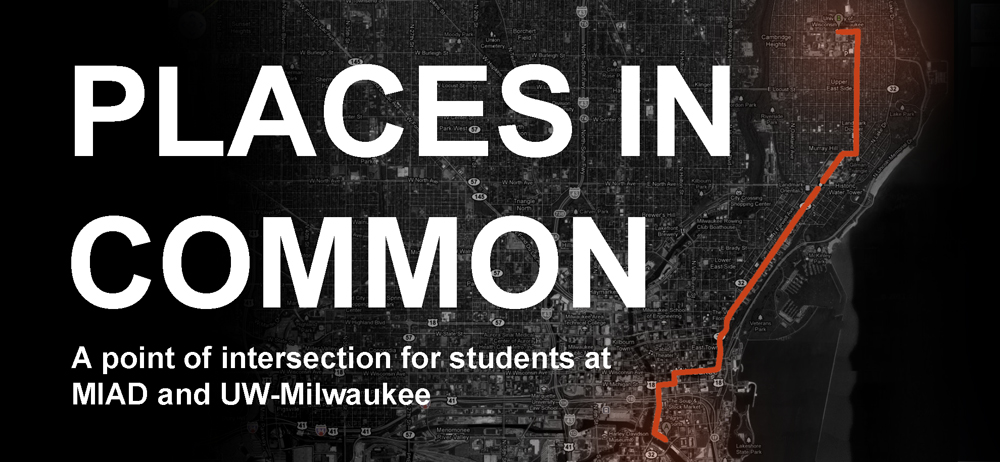
Our drawing was constructed by randomly chosing cars to follow.  Once we started to follow a car, we trailed it until it reached its destination.  At that point we picked a new car to follow.  The first car took us from MIAD to an apartment near UWM. The next car we followed turned a corner and parked.  The next car took us to a parking lot on the corner of Plankinton Ave and Kilbourn Ave.  Our final car led us to the Aurora West Allis Medical Center on Lincoln Ave.  In our car we discussed if the lead car's driver knew we were following him or her.  In addition, we hypothesized what his or hers destination was.

Our return trip to MIAD was significantly different than our original drawing.  This inspires questions about "the journey" one chooses to take to a destination.  How does one select a route?  How do we navigate?  Major influences include but are not limited to: available modes of transportation, access to technology, environmental factors, time, aesthetics, knowledge, preference, and personal experience.  While navigation is not uniquely human, our relationship with choice and travel is.  

Navigation has evolved from hardwired survival instincts into an amalgamation of complex components embodying individualism.

Monday, October 10, 2011

GPS Drawing

For our GPS drawing, we decided not to travel in any straight lines. Every time we came across an intersection, whether it be two streets or a street and an alley, etc. we took turns deciding whether to turn left or right. It was interesting to navigate the city in this way - we noticed a lot of buildings and backstreets that would otherwise go unnoticed on our usual routes. Funny thing was, as soon as we felt like we were getting somewhere entirely new and unfamiliar, a wrong turn onto the freeway put us right back where we started.

Thursday, October 6, 2011

Doors open Milwaukee

For doors open Milwaukee I went to the US Bank first. The view was neat, it's a bummer it was rain and foggy, I'm sure the Lake would have looked nice. The men that were working said they were thinking about having it open to the public more often.
The view wasn't the only cool thing about the bank. I really enjoyed the pipes in the building, it had an interesting mood.

Next I went to Hotel Foster. They had a really nice art collection.

The structure of the building was very interesting, even down to the carpets.

Wednesday, October 5, 2011

GPS Drawing: follow the trail of empty beer cans through the woods

Nikki's Awful City Forest Adventure


EveryTrail - Find the best Hiking near Milwaukee, Wisconsin


So I had the idea to try to make a peace sign using the locust street bridge as the middle line going through the middle. I wanted to make a peace sign because the river would break through the sign, so the circle would not be complete, this would represent the segregation in Milwaukee. However I wasn't able to start until 7 due to my class schedule. When I first start dthe walk in was beautiful , however it soon got dark. Once it was dark it became harder and harder to see through the woods and even though I had the map to follow the woods became a big obsticals with hills and trees blocking the way. after being covered in burs i somewhat gave up on making the peace sign and was stuck behind a fence in the nasty woods and finally got out at Locust street.
So yep thats my adventure!

Places We Go

We decided to visit the places that we go to most, and once there, circle them as many times we are there during the week. The whole process took 2 1/2 hours. It was pretty entertaining while circling each place, people started to notice.